Length: 15.8 miles round trip
Elevation Change: 4016' gain
Season: Late Spring thru early Fall
Difficulty: Very Difficult - steep and long
Permit: Not Required at Multnomah Falls TH
Features:
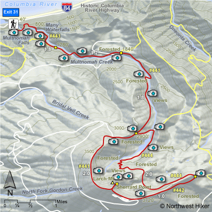
This challenging hike has lots of waterfalls, lots of elevation
and lots of miles. Starting at the Multnomah Falls trail head, you hike up past the
top of the falls, following Multnomah Creek for about four and a half miles to a
junction that allows you to make an excellent loop hike out of this adventure.
Follow Trail #444 for about 2.75 miles where it connects to Trail #424 and leads
you to the top of Larch Mountain and Sherrard Point, where you enjoy the only real
vistas during this long forested hike. From there follow Trail
#441 back down the mountain to Multnomah Falls where you began.
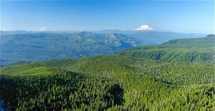 Mt. Rainier and Mt. Adams as seen from Sherrard Point
at the summit of Larch Mountain.
|
|
How to get there:
From I-84 take Exit #31/Multnomah Falls. Park in the parking lot and walk under
the footbridge to Multnomah Falls Lodge.
Alternatively, take I-84 east to Exit #28/Bridal Veil and drive east on the
Historic Columbia River Highway to the Multnomah Falls Lodge parking area.
Coming from the east on I-84, take exit 35 (Ainsworth Park) and drive about 4 miles west on the
Historic Highway to reach the Multnomah Falls Lodge parking area and trailhead.
From Portland, due to overcrowding at Multnomah Falls in peak season, we highly recommend for convenience and safety, that
you consider using the Gorge Transit bus .
The price is low and the convenience is high.
|