Length: 7 Mile Round Trip
Elevation Change: 1800' Elevation Cumulative gain
Season: Mid-Summer thru Fall
Difficulty: Challenging
Permit: NW Forest Pass Required
Please be advised that this hike is not accessable,
because the access road is washed out as of the spring of 2009.
Features:
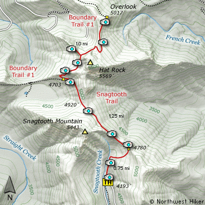
The Hike to the Hat Rock Overlook via Snagtooth Ridge trail begins
along Forest Road #9341. The trail starts climbing rather
modestly, but within a quarter mile it becomes extremely
steep. Most of this hike occurs within dense forest with
occasional yet outstanding viewpoints.
At about 3/4 miles the trail passes over the crest of Snagtooth
ridge and there is an outstanding viewpoint for your pleasure.
The trail continues to climb vigorously as it makes its way
over the northeast side of Snagtooth. There are occasional
views of the surrounding Dark Divide and Mt. Adams to the east.
At about 2 miles the trail joins the Boundary Trail #1. At
this point, turn right and follow Trail #1 uphill along the
western flank of Hat Rock. Within a half mile the tail
comes out on a large cliffy area which is the goal of this
hike. This cliff area provides our standing views to the
west.
If you hike east along the Boundary Trail for another half
mile, you will be treated to outstanding vistas of Mt. Adams,
Juniper Ridge, and Mt. Rainier to the north.
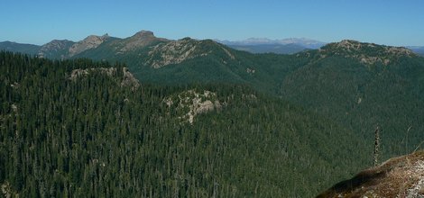
Looking northeast at Juniper Ridge from the Hat Point trail
|
How to get there:
NEW!
Click for PDF Directions Map of this Hike
NEW!
Click for PDF Directions Map of this Hike
From the junction of Forest Road 90 and Forest Road 25 at the far eastern end
of Swift Creek Reservoir, travel east on FR90, crossing the Lewis River, and heading
upstream for about 4 miles. You will come to the junction of the Curely Creek
Cutoff Road, which comes from the south and the Wind River Highway.
From this junction continue east on FR90 for about another 9 miles and FR90 will cross
the Lewis River. In the next several miles you will pass the 3 approaches to
the Lewis River Falls, which are hikes on this CD.
At about another three and a half miles after the river crossing, you will come to Forest Road 93 on your left.
Turn left, or north, onto FR93 and follow it uphill for another 6 miles to the junction
of Forest Road 93 and Forest Road 9341. Bear right onto FR9341 and follow it another
4.7 miles to the trailhead for this hike.
|